Ski Runs & Terrain Park
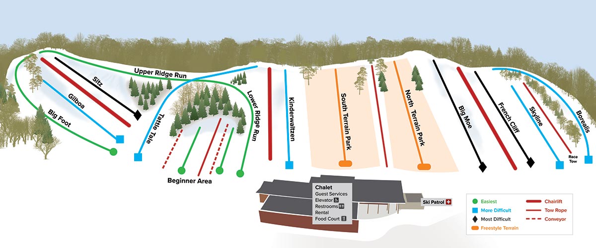
RUNS
| Big Foot | Easiest | Closed |
| Upper Ridge Run | Easiest | Closed |
| Lower Ridge Run | Easiest | Closed |
| Tattle Tale | More Difficult | Closed |
| Beginner Area | Easiest | Closed |
| Kinderwaltzen | More Difficult | Closed |
| Gilboa | More Difficult | Closed |
| Big Moe | Most Difficult | Closed |
| Sitz | Most Difficult | Closed |
| French Cliff | Most Difficult | Closed |
| Skyline | More Difficult | Closed |
| Borealis | More Difficult | Closed |
TERRAIN PARK
| South Terrain Park | Freestyle Terrain | Closed |
| North Terrain Park | Freestyle Terrain | Closed |
Trail Designations
Three Rivers Parks promotes responsible ski-area behavior. Know your ability and make yourself familiar with ski-area markings. Skiers and snowboarders should begin with the easiest trail and work up, no matter their ability level. All of the trails at Hyland Hills Ski Area are designated with the common trail marking symbols found throughout North America.
Green circle = easiest
Blue square = more difficult
Black diamond = most difficult
Orange oval = freestyle terrain (may include half-pipes, terrain parks and terrain features)